Projects & Plans
Featured Projects
Discover our featured projects: A showcase of innovative and impactful initiatives that are shaping our community’s future. Explore these projects to learn how they’re improving transportation, infrastructure, and quality of life in our metropolitan area.
Metropolitan Transportation Plan (MTP)
This long-term vision outlines the region’s transportation goals, major projects, and funding priorities over the next 20-30 years. Read more
Unified Planning Work Program (UPWP)
The TIP is a shorter-term plan, usually spanning 4-6 years, specifying which transportation projects will receive funding and when they’ll be implemented.
Read more
Transportation Improvement Program (TIP)
This document details the planning activities, studies, and budgets to support transportation planning and decision-making within the metropolitan area.
Read more
Title VI and Public Participation
These plans outline how the public can contribute to transportation planning, fostering community involvement and input. Read more
Projects & Plans
Current FY Projects
Lorem ipsum dolor sit amet, consectetur adipiscing elit, sed do eiusmod tempor incididunt ut labore et dolore magna aliqua. Ut enim ad minim veniam, quis nostrud exercitation ullamco laboris nisi ut aliquip ex ea commodo consequat.
Required Plans and Documents
Lorem ipsum dolor sit amet, consectetur adipiscing elit, sed do eiusmod tempor incididunt ut labore et dolore magna aliqua. Ut enim ad minim veniam, quis nostrud exercitation ullamco laboris nisi ut aliquip ex ea commodo consequat.
Document Resources
Bike and Pedestrian Masterplan
Document Resources
Public Participation Plan
Document Resources
Title VI Plan
What is it?
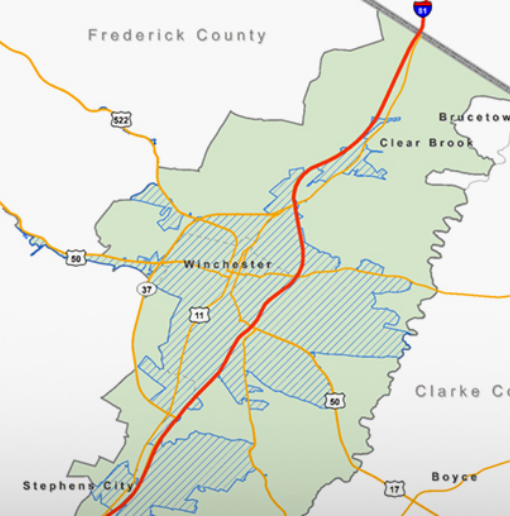
The Metropolitan Transportation Plan (MTP) defines long-range transportation needs for the City of Winchester, surrounding developed areas of Frederick County, and areas expected to become developed over the next 20 years; and proposes strategies for addressing those needs. Through the MTP, the MPO establishes its priorities for the investment of federal transportation dollars.
Reviewed and updated every five years to confirm its validity and its consistency with the most current forecasts and trends in population, employment, land use, travel, congestion and economic activity, the MTP must cover at least a 20-year planning horizon. WinFred MPO’s 2045 Metropolitan Transportation Plan was adopted in November 2022.
In accordance with Federal law, the plan must contain the following elements:
- Identification of transportation facilities that should function as an integrated metropolitan transportation system
- Performance measures and targets
- A system performance report
- A discussion of potential environmental mitigation activities
- A financial plan that demonstrates how the adopted plan can be implemented
- Operational and management strategies to improve the performance of existing facilities
- Capital investment and other strategies to preserve the system and provide for future needs; and
- A discussion of transportation and transit enhancement activities including public and private intercity bus service.
Why should I care?
Much of what we call “transportation infrastructure” – streets, highways, bridges, and even transit buses, sidewalks and bike trails – is paid for by you, the taxpayer. You have a voice in determining the shape of our transportation system: how it affects the character of our community, how safe it is, and whether it opens or blocks access to opportunity – for young and old, driver and non-driver. The MTP planning process offers an opportunity to let your voice be heard.
View the Final Plan
The 2045 update to the Metropolitan Transportation Plan was adopted by the Policy Board in November 2022. Read the final plan here.
MPO staff developed an interactive webmap to assess how all of the comments submitted during the public enagement period corresponded to the projects selected for the Constrained Long Range Plan. View the MTP Comment Webmap.
Finished/Archived Projects
Study Overview
Bike sharing in urban communities has grown exponentially in recent years as alternative from of transportation and economic development tool. A typical bike share program involves automated kiosks that allow users to rent a bicycle for a short period of time to travel throughout the city for a low cost. The bicycle can then be returned at any kiosk when the trip is over. Access to bikeshare can help to reduce traffic congestion, provide alternative transportation to work, act as a tourist attraction, increase access to economic opportunity and promote public health. The City of Winchester is interested in how a bike share system could benefit the community in a variety of ways including economic development and alternative modes of transportation in the downtown core.
At the beginning of 2020, Winchester-Frederick County MPO contracted with Racey Engineering of Luray and EPR-PC of Charlottesville to conduct a bikeshare feasibility study for the City of Winchester. The consulting team conducted a review of bikeshare systems operating in cities similar in size to Winchester, conducted a public survey, and held multiple stakeholder meetings in order to gain feedback and insight that fully expanded on and addressed the following:
- Identify potential partner companies and/or pilot projects to implement and administer bikeshare programs
- Provide options for funding schemes and program management
- Inventory existing bike lanes and bike paths and identification of potential bike lanes and paths that would enhance the network connectivity
- Establish performance goals and measurement tools
- Analyze potential economic development impacts associated with bikesharing, including impacts on tourism and job accessibility
- Develop a comprehensive logistical plan that includes:
- Prime kiosk locations (particularly in the downtown core)
- Fleet management
- User safety requirements
- Theft protection
- Promotion
- User fees
- Develop options for a phased implementation strategy
In the Fall of 2020, the project team kicked of Phase II of the Bikeshare Study. The goal of Phase II was to review and implement Phase I recommendations and address barriers to bikeshare including bike safety concerns, public awareness of biking in the City, and the need for additional infrastructure. Phase II tasks included:
- An in-depth analysis of bicycle safety, including previous academic research, and VDOT crash data in order to inform safety recommendations
- A community survey was administered in the Spring of 2021 to gauge the public’s perception of bicycle safety in the City
- Updates to the current Winchester-Frederick County Bike Map to reflect previous and planned changes, including the Green Circle Trail, and recommendations to update the existing bike network
- Development of a bike safety marketing campaign
Establishment of a Bikeshare Taskforce to oversee project implementation
Benefits of Study Recommendations
-
- Introduction of an affordable, green, and healthy transportation option for residents and visitors
- Improved bike safety through network improvements
- Improved bike safety awareness through a comprehensive marketing campaign
Study Timeline
- Study kick-off meeting was held in February 2020
- Stakeholder outreach meetings, held via Zoom, took place in April and early May of 2020
- A public survey to gauge interest in bikeshare was administered through May and June of 2020
- A preliminary report of Phase I finding and recommendations was delivered and presented to City Council in the summer of 2020. The preliminary report provided a foundation for the follow-up Phase II study.
- Phase II kicked off in October of 2020
- During the Winter of 2020, Consultants conducted a thorough review of existing bike safety literature, VDOT crash data, and the existing and planned bike network.
- A public bike safety survey was administered in the spring of 2021
- In May and June of 2021, Consultants developed recommendations based on previous research and survey responses and delivered a series of presentations to the following:
- MPO Technical Advisory Committee
- MPO Policy Board
- City of Winchester Pedestrian and Economic Development Committee
- In the summer of 2021, consultants developed a bike safety marketing campaign
- Phase II is projected to wrap up by the end of 2021 with final desks that include:
- Collaboration with the City’s Communication staff to finalize a bike safety marketing strategy consistent with the City’s ongoing marketing structure
- Delivery of a final report that includes Phase I and Phase II findings and recommendations
Document Resources
Study Overview
Millwood Avenue (US Routes 17/50/522) just west of I‐81 Exit 313 has several signals, intersections and driveways over a short section of roadway. In addition, Exit 313 is programmed to be improved with replacement of both bridge spans. To improve roadway safety and operation, the City of Winchester has proposed the following:
- Signals at Mall Boulevard will be removed, the existing intersection closed for left turns to/from Millwood Avenue westbound, and Mall Boulevard will be made right‐in and right‐out.
- A new median cut and unsignalized left turn lane serving the Clarion Inn/Lee‐Jackson Conference Center/Perkins will be established west of the existing Mall Boulevard intersection for westbound Millwood Avenue ingress.
- An additional westbound left turn lane will be added on the approach to the Millwood Avenue/Apple Blossom Drive intersection; and the eastbound right‐turn lane approaching the I‐ 81 southbound on‐ramp will be extended.
The purpose of this project is to perform preliminary engineering of Millwood Avenue from the I‐81 interchange to Apple Blossom Drive to set the design for future development of construction drawings, inform the public and set the project budget.
Benefits of Study Recommendations
- Improved corridor operations and progression through intersection improvements and access management
- Safer pedestrian movement with a new pedestrian bridge
- Improved roadway aesthetics and gateway enhancements
Study Timeline
- Study Kick-Off Meeting held on January 24, 2020
- Preliminary plans completed March 2021
Document Resources
Study Overview
Route 11 North, Martinsburg Pike, has in recent years experienced a high incidence of vehicle crashes and daily traffic delays. Linking I-81 with nearby industrial parks, this road serves a large volume of trucks. The configurations of intersections, the surrounding network of streets and roads, and the I-81 interchange each contribute to the safety and congestion problems. In 2016 the WinFred MPO initiated a study to identify cost-effective solutions. Identified solutions for which construction funding is requested include:
- A roundabout intersection at Route 11 and Old Charles Town Road
- Relocation of the northbound I-81 Exit 317 off-ramp to the current Redbud Road alignment and intersection with Route 11
- Reconfiguration of Route 11 to a “diverging diamond” interchange with I-81, allowing left turns from Route 11 onto I-81 without crossing opposing traffic
- Extensions of the northbound turn lane approaches on Welltown Road and Amoco Lane
- A slip ramp from northbound to southbound Route 11 (u-turn) and southbound Route 37 just south of the Crown Road/Pactiv Way intersection.
Benefits of Study Recommendations
- Reduced traffic delay, improved traffic flow, from northbound Route 11 to northbound I-81
- Easier exit from Old Charles Town Road to southbound Route 11 via roundabout intersection
- Reduced delay at Route 11 signalized intersections with Crown Lane/Pactiv Way and Welltown Road/Amoco Lane
- Improved safety; fewer crashes
Study Timeline
- Project initiated in MPO’s Unified Planning Work Program, April 2015
- Request for Proposals issued November 2, 2015
- Project scoping meeting, February 5, 2016
- Contract for North Winchester Interchange Alternatives Analysis Report signed June 6, 2016
- Project re-scoped to assume preservation of existing bridges, rather than replacement. Notice to Proceed issued for North Winchester Area Study Phase I (Redbud Road to Old Charles Town Road) on May 8, 2018
- Phase II (Redbud Road to Crown Lane/Pactiv Way) contract executed on February 12, 2019
- SMART SCALE pre-applications for diverging diamond interchange, roundabout and intersection improvements submitted April 17, 2020
- Phase III (supporting documentation for interchange modification) contract executed on May 1, 2020
- Phase III completed August 2020
Document Resources
Document Resources
LFCC Transit Feasibility Final Report
Document Resources
Stephens City Sidewalk Audit
Document Resources
Millwood Ave. Study Final Report
Project Coming Soon
Lorem ipsum dolor sit amet, consectetur adipiscing elit, sed do eiusmod tempor incididunt ut labore et dolore magna aliqua. Ut enim ad minim veniam, quis nostrud exercitation ullamco laboris nisi ut aliquip ex ea commodo consequat.
Lorem ipsum coming soon
Get in touch!
Get in touch with us! Have questions, feedback, or inquiries? Contact our team today. We’re here to assist you and eager to hear from you.